I'm often amazed at our lack of knowledge about history. Ordinary people are hungry for this information, yet the organizations responsible to disseminate these facts seem to have an agenda to keep us in the dark. This is especially true when it comes to our ancient human history.
I won't hold you in suspense with this article: The Ark of Noah has been found. It's real. I'll describe the evidence in some detail and end with the historical and religious implications.
How It Was Discovered
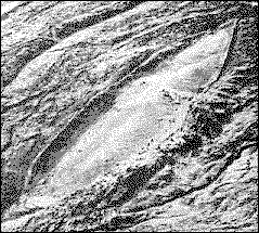
In 1959, Turkish army captain Llhan Durupinar discovered an unusual shape while examining aerial photographs of his country. The smooth shape, larger than a football field, stood out from the rough and rocky terrain at an altitude of 6,300 feet near the Turkish border with Iran.
Image may be NSFW.
Clik here to view.
noahs ark found
Photo: http://www.viewzone.com/noahx.html
Capt. Durupinar was familiar with the biblical accounts of the Ark and its association with Mount Ararat in Turkey, but he was reluctant to jump to any conclusions. The region was very remote, yet it was inhabited with small villages. No previous reports of an object this odd had been made before. So he forwarded the photographic negative to a famous aerial photography expert named Dr. Brandenburger, at Ohio State University.
Brandenburger was responsible for discovering the Cuban missile bases during the Kennedy era from reconnaissance photos, and after carefully studying the photo, he concluded: "I have no doubt at all, that this object is a ship. In my entire career, I have never seen an object like this on a stereo photo."
Image may be NSFW.
Clik here to view.
Photo: http://www.viewzone.com/noahx.html
In 1960 the picture [above] was published in LIFE magazine under the heading of Noahs Ark? That same year a group of Americans accompanied Capt. Durupinar to the site for a day and a half. They were expecting to find artifacts on the surface or something that would be unquestionably related to a ship of some kind. They did some digging in the area but found nothing conclusive and announced to the anxiously waiting world that it appeared to be a natural formation.
Most of the global media turned away from the find and it became a non-story.
In 1977 Ron Wyatt visited the site. Obtaining official permission, Ron and others conducted more thorough research over a period of several years. They used metal detection surveys, subsurface radar scans, and chemical analysis -- real science -- and their findings were startling. The evidence was undeniable. This was the Ark of Noah.
The Visual Evidence
The first part of the survey was to examine the object and take its measurements. The shape looked like hull of a ship. One end was pointed as you would expect from bow [below: D] and the opposite end was blunt like a stern. The distance from bow to stern was 515 feet, or exactly 300 Egyptian cubits. The average width was 50 cubits. These were the exact measurements mentioned in the Bible.
Image may be NSFW.
Clik here to view.
Photo: http://www.viewzone.com/noahx.html
On the starboard side (right) near the stern there were four vertical bulges protruding from the mud , at regular intervals, that were determined to be the "ribs" of the hull [see below]. Opposite to these, on the port side, a single rib [A] protrudes from the mud. You can see its curved shape very clearly. Surrounding it are more ribs, still largely buried in the mud, but visible upon close examination.
Remember that this object, if it is the Ark, is extremely old. The wood has been petrified. Organic matter has been replaced by minerals from the earth. Only the shapes and traces of the original wood remain. Perhaps this is why the expedition in 1960 was disappointed. They anticipated finding and retrieving chucks of wood, long since eroded.
Image may be NSFW.
Clik here to view.
Photo: http://www.viewzone.com/noahx.html
From the position of the object in the middle of an obvious mud flow, it is obvious that the object slid down more than a mile from its original location. Geologists believe it was originally over 1000 feet higher in the mountain and encased in a shell of hardened mud. They think that an earthquake in 1948 cracked the mud shell and revealed the structure. This is confirmed by stories from the surrounding villagers who tell of its "sudden appearance" around that time.
Image may be NSFW.
Clik here to view.![zzid4-ark5.gif]()
Photo: http://www.viewzone.com/noahx.html
Biblical accounts of the Ark describe it as having as many as six levels. The assumed shape of the Ark seems consistent with the bulge [C] in the middle of the object. In fact, as we will soon learn, radar scans of the structure suggest that this bulge is the collapsed debris of these levels.
Although most people think of the Ark as being rectangular, that only applies to the top decks. The sleek shape of the hull is necessary to enable the huge ship to remain stable in the water and survive tremendous waves.
Ground Penetrating Radar
The human eye needs to see reflected light to recognize an object. To visualize what remains below the earth, scientists use microwaves which can penetrate the ground and bounce back when they hit something solid. This technique is commonly used to locate oil and other minerals. Called Ground Penetrating Radar (GPR), the apparatus us made from an antenna that transmits, then listens to receive the "echo" and prints the result on a piece of paper. The delay and strength of this echo tell the geologists how solid and at what depth the objects are under the earth.
Image may be NSFW.
Clik here to view.![vl03u-ark6.jpg]()
Photo: http://www.viewzone.com/noahx.html
The team of geologists didn't scan the entire object. Instead, they marked out lines that crossed the object with yellow tape. Then they dragged the antenna (about the size of a lawnmower) over the lines and watched the output on the paper recorder. When they got a strong "hit" -- meaning there was something solid underneath -- they would record the position on the tape [above]. Later, when they made a map of the object, the tape and the location of the "hits" they realized that there was indeed a structure underneath the mud.
"This data does not represent natural geology. These are man made structures. These reflections are appearing too periodic... too periodic to be random in that type of natural pace." - Ron Wyatt of SIR Imaging team
noahs ark found
Photo: http://www.viewzone.com/noahx.html
The radar cans revealed this structure [above] under the mud. The symmetry and logical placement of these objects shows that this is unmistakably a man made structure, most likely the Ark of Noah.
I won't hold you in suspense with this article: The Ark of Noah has been found. It's real. I'll describe the evidence in some detail and end with the historical and religious implications.
How It Was Discovered
In 1959, Turkish army captain Llhan Durupinar discovered an unusual shape while examining aerial photographs of his country. The smooth shape, larger than a football field, stood out from the rough and rocky terrain at an altitude of 6,300 feet near the Turkish border with Iran.
Image may be NSFW.
Clik here to view.
noahs ark found
Photo: http://www.viewzone.com/noahx.html
Capt. Durupinar was familiar with the biblical accounts of the Ark and its association with Mount Ararat in Turkey, but he was reluctant to jump to any conclusions. The region was very remote, yet it was inhabited with small villages. No previous reports of an object this odd had been made before. So he forwarded the photographic negative to a famous aerial photography expert named Dr. Brandenburger, at Ohio State University.
Brandenburger was responsible for discovering the Cuban missile bases during the Kennedy era from reconnaissance photos, and after carefully studying the photo, he concluded: "I have no doubt at all, that this object is a ship. In my entire career, I have never seen an object like this on a stereo photo."
Image may be NSFW.
Clik here to view.
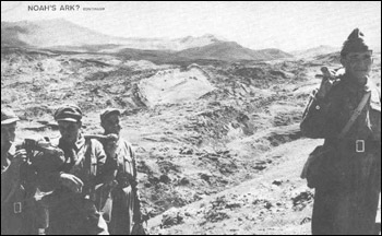
Photo: http://www.viewzone.com/noahx.html
In 1960 the picture [above] was published in LIFE magazine under the heading of Noahs Ark? That same year a group of Americans accompanied Capt. Durupinar to the site for a day and a half. They were expecting to find artifacts on the surface or something that would be unquestionably related to a ship of some kind. They did some digging in the area but found nothing conclusive and announced to the anxiously waiting world that it appeared to be a natural formation.
Most of the global media turned away from the find and it became a non-story.
In 1977 Ron Wyatt visited the site. Obtaining official permission, Ron and others conducted more thorough research over a period of several years. They used metal detection surveys, subsurface radar scans, and chemical analysis -- real science -- and their findings were startling. The evidence was undeniable. This was the Ark of Noah.
The Visual Evidence
The first part of the survey was to examine the object and take its measurements. The shape looked like hull of a ship. One end was pointed as you would expect from bow [below: D] and the opposite end was blunt like a stern. The distance from bow to stern was 515 feet, or exactly 300 Egyptian cubits. The average width was 50 cubits. These were the exact measurements mentioned in the Bible.
Image may be NSFW.
Clik here to view.
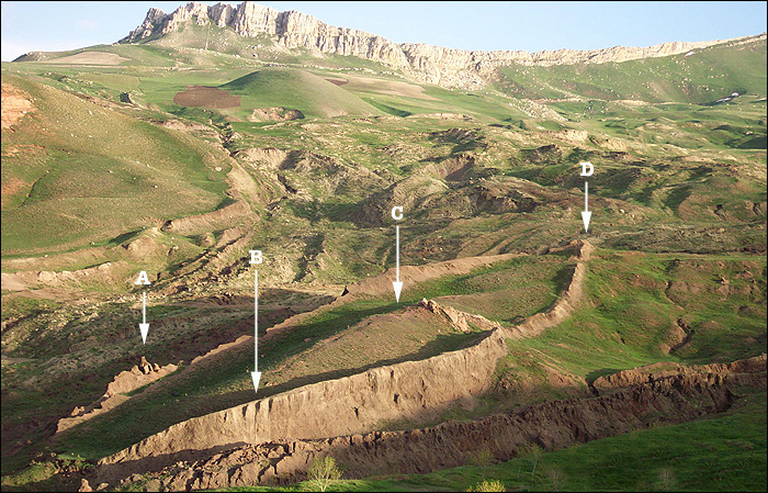
Photo: http://www.viewzone.com/noahx.html
On the starboard side (right) near the stern there were four vertical bulges protruding from the mud , at regular intervals, that were determined to be the "ribs" of the hull [see below]. Opposite to these, on the port side, a single rib [A] protrudes from the mud. You can see its curved shape very clearly. Surrounding it are more ribs, still largely buried in the mud, but visible upon close examination.
Remember that this object, if it is the Ark, is extremely old. The wood has been petrified. Organic matter has been replaced by minerals from the earth. Only the shapes and traces of the original wood remain. Perhaps this is why the expedition in 1960 was disappointed. They anticipated finding and retrieving chucks of wood, long since eroded.
Image may be NSFW.
Clik here to view.
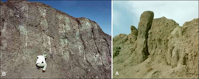
Photo: http://www.viewzone.com/noahx.html
From the position of the object in the middle of an obvious mud flow, it is obvious that the object slid down more than a mile from its original location. Geologists believe it was originally over 1000 feet higher in the mountain and encased in a shell of hardened mud. They think that an earthquake in 1948 cracked the mud shell and revealed the structure. This is confirmed by stories from the surrounding villagers who tell of its "sudden appearance" around that time.
Image may be NSFW.
Clik here to view.
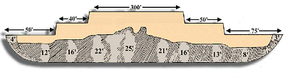
Photo: http://www.viewzone.com/noahx.html
Biblical accounts of the Ark describe it as having as many as six levels. The assumed shape of the Ark seems consistent with the bulge [C] in the middle of the object. In fact, as we will soon learn, radar scans of the structure suggest that this bulge is the collapsed debris of these levels.
Although most people think of the Ark as being rectangular, that only applies to the top decks. The sleek shape of the hull is necessary to enable the huge ship to remain stable in the water and survive tremendous waves.
Ground Penetrating Radar
The human eye needs to see reflected light to recognize an object. To visualize what remains below the earth, scientists use microwaves which can penetrate the ground and bounce back when they hit something solid. This technique is commonly used to locate oil and other minerals. Called Ground Penetrating Radar (GPR), the apparatus us made from an antenna that transmits, then listens to receive the "echo" and prints the result on a piece of paper. The delay and strength of this echo tell the geologists how solid and at what depth the objects are under the earth.
Image may be NSFW.
Clik here to view.
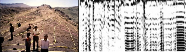
Photo: http://www.viewzone.com/noahx.html
The team of geologists didn't scan the entire object. Instead, they marked out lines that crossed the object with yellow tape. Then they dragged the antenna (about the size of a lawnmower) over the lines and watched the output on the paper recorder. When they got a strong "hit" -- meaning there was something solid underneath -- they would record the position on the tape [above]. Later, when they made a map of the object, the tape and the location of the "hits" they realized that there was indeed a structure underneath the mud.
"This data does not represent natural geology. These are man made structures. These reflections are appearing too periodic... too periodic to be random in that type of natural pace." - Ron Wyatt of SIR Imaging team
noahs ark found
Photo: http://www.viewzone.com/noahx.html
The radar cans revealed this structure [above] under the mud. The symmetry and logical placement of these objects shows that this is unmistakably a man made structure, most likely the Ark of Noah.